
6. The Whatcom Region’s Transportation Strategies
Informed by the Whatcom Region’s transportation system goals, federal and state requirements, and adopted plans of our partners, this section presents the strategies that guide WCOG’s evaluation of transportation system needs and collaboration with regional partners to select investments.
6.1 WCOG’s Organization and Planning Work Program Strategies
6.1.1 Governance
As discussed in the Introduction, the Whatcom region has chosen to fulfill its federal and state regional transportation planning requirements under the umbrella of WCOG – originally created in 1966 as a state-authorized regional planning conference. Both the federally required MPO and state RTPO are established as one Whatcom Transportation Policy Board (WTBP). The WTPB is a a subcommittee of WCOG’s Council Board.
6.1.2 Unified Planning Work Program
Each year, WCOG develops and submits a Unified Planning Work Program (UPWP) for approval by the Washington State Department of Transportation (WSDOT), the U.S. Federal Highways Administration (FHWA), and U.S. Federal Transit Administration (FTA). The UPWP describes in detail how WCOG will fulfill its MPO and RTPO obligations. While many of the planning strategies expanded on below are also discussed in the UPWP, the UPWP documents WCOG’s current, one-year allocation of funding to specific activities. This plan’s discussion of strategies pertains to the full 20-year planning horizon (at least until the plan is updated again in five years).
6.1.3 Staff and TTAG
The MPO/RTPO (the Policy Board) hires a professional staff to assist in carrying out its UPWP.
The MPO/RTPO is also advised by the Transportation Technical Advisory Group (TTAG), planning and public-works staff from its member-jurisdictions and agencies.
6.1.4 Public Participation
Regional planning and decision making starts with public input and ongoing opportunities for community engagement. WCOG’s strategy for public participation is regularly updated and documented in its Public Participation Plan. One of the practices defined in this plan is the organization and facilitation of the Community Transportation Advisory Group (CTAG). CTAG, jointly administered by WCOG and the Whatcom Transportation Authority (WTA), is a voluntary forum for community participation in decision making about transportation planning, construction, and operations.
6.1.5 Least-cost Planning
The Washington Administrative Code requires regional transportation plans prepared by RTPOs to be based on a “least-cost planning methodology appropriate to the region.” Least-cost planning (LCP) is the process by which a region pursues its transportation goals using the most cost-effective mix of options. Furthermore, the process should:
- Consider both transportation supply strategies like building or widening roads, adding new transit service; and demand strategies like converting general-purpose lanes into high-occupancy vehicle lanes, transportation demand management programs like Whatcom Smart Trips, etc.
- Consider both direct costs like infrastructure, operations, preservation and debt service, and indirect costs such as safety, travel time, air quality, public health and habitat loss.
To meet this requirement, WCOG has done or is doing the following:
- Adopted regional goals that reflect the expectation that the future effectiveness of the regional transportation system should, and will, rely on a mix of options.
- In addition to calling for strategic increases in the supply of transportation infrastructure and services, WCOG has adopted regional demand strategies, most notably the regional TDM program, Whatcom Smart Trips. Through this program, WCOG works closely with the jurisdictions and transit providers to support the future effectiveness and attractiveness of transportation modes other than single-occupancy vehicles.
- By adopting regional goals and strategies as a means to both develop and continuously improve performance measures, WCOG’s regional planning activities can include benefit-cost analyses that include indirect cost factors (such as safety, travel time, health, environmental quality), which are essential to a LCP approach
- As it relates to the desired LCP outcome of “the most cost-effective mix of options,” WCOG has adopted the regional goals of providing all types of transportation (multimodal), and maintaining existing infrastructure in good, operating condition (preservation). This entails: making the best use of available information to identify alternatives; evaluating relative direct and indirect costs and benefits as described above; and selecting alternatives that the region can afford and that provide the most expected benefit for the least cost.
6.1.6 Environmental Mitigation
Federal regulations require that long-range transportation plans “include a discussion of types of potential environmental mitigation activities and potential areas to carry out these activities, including activities that may have the greatest potential to restore and maintain the environmental functions affected by the plan.” Accordingly, MPOs are required to seek consultation with federal, state and tribal land-management, wildlife and regulatory agencies during the preparation of long-range transportation plans. Appendix E includes a table of agencies that were provided draft versions of this plan for review.
6.2 System Performance Monitoring
Planning investments and other actions to best pursue our regional transportation goals requires data-based monitoring of trends and current conditions alongside selected measures of system performance.
WCOG doesn’t attempt to monitor every element of the regional transportation described in Section 2 but it does undertake several performance monitoring strategies and compile a biannual systems performance report incorporated into this plan as Appendix G.
Performance monitoring has always been a key element of WCOG’s MPO and RTPO planning activities but state and federal requirements specifying measures, targets, have been refined and added over time. Thus, this subsection identifies the long-standing core activities as well as the requirement-based planning activities that currently compose WCOG’s performance-monitoring work
6.2.1 Data Collection
Measurement requires data. WCOG compiles needed data from various sources (e.g. Census, WA Office of Financial Management, local government land-use data, etc.) but also acquires and collects regionally pertinent data directly. These include:
- Traffic and intersection turning counts (directly hiring traffic counting contractors)
- Conducting periodic regional household travel surveys (origin, destination, travel type, times, mode split, corresponding demographics, etc.)
- Large scale public engagement questionnaires.
- Device-generated location-based-services data (from companies like StreetLight)
6.2.2 Regional Transportation Demand Model
To produce detailed, data-based analyses and visualizations of current and forecast transportation system conditions (trip volumes, vehicle volumes, road and traffic conditions, etc.) WCOG maintains a regional transportation demand model. This model is the basis for the base-year and forecast-year assessments discussed in Section 4.
6.2.3 Performance Based Planning and Programming
Revision of federal state and MPO planning rules in 2015 introduced the Performance Based Planning and Programming (PBPP) framework.
Under PBPP, MPOs like WCOG are required to set targets for specific areas of performance using prescribed or other approved measures:
- Safety (five trend-based measures of fatal and serious-injury crashes on all public roadways)
- System Performance (travel time and travel time reliability on major roadways), and
- State of good repair (condition of pavement, bridges, and transit assets)
These measures and targets are then incorporated into selection processes for regional transportation projects that use federal funds that are sub-allocated to MPOs (For more information, see WCOG’s Transportation Improvement Program).
System Performance Report
PBPP rules also require MPOs to periodically update a regional system performance report. WCOG’s System Performance Report includes reporting on the above, federally required measures and targets as well as several other regional measures. WCOG’s regional measures are developed for selected interjurisdictional corridors.
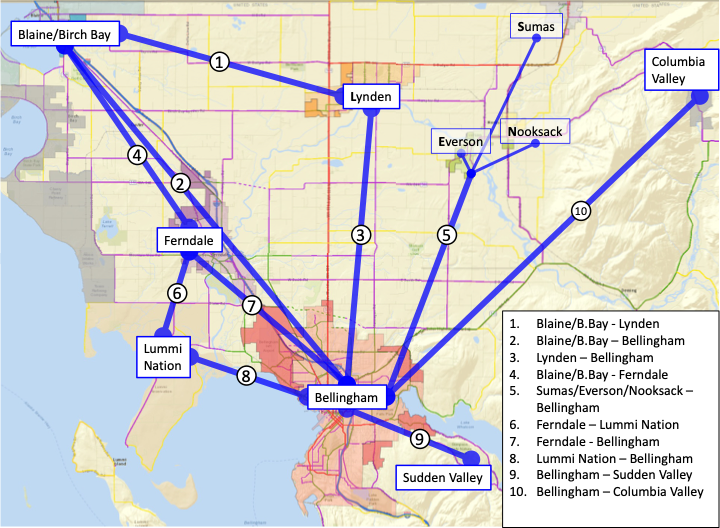
WCOG’s Interjurisdictional Corridors
As part of adopting performance-based planning practices, WCOG has identified interjurisdictional corridors that serve as the principal connection between two or more communities in Whatcom County. For each of these corridors a generalized geography is identified so as to assess the modes and system components that facilitate mobility along the corridor (roads, transit service, trails, etc.). Identification of regional corridors provides a framework for coordination between jurisdictions and agencies with operational responsibilities on each corridor (Whatcom County, WTA, WSDOT, etc.). With performance measures applied to these corridors, WCOG and its partners can track progress toward meeting established operational goals and more clearly identify system needs and the investments necessary to meet them.
Figure 17: Whatcom’s Ten Regional Corridors
Level of Service (LOS)
Washington state law (RCW 47.80.030) requires RTPOs (such as WCOG) to develop and establish LOS standards (in collaboration with WSDOT) for the regionally significant state routes within their planning area.
Based on standardized measures of road capacity documented in the Highway Capacity Manual, the long-established LOS for regionally significant state routes in the Whatcom region uses a peak-hour vehicle volume measured as a percentage of the subject road segment’s designed capacity. For regionally significant state routes in urban areas, the standard is between 80 and 89 percent of capacity (“LOS D”). For regionally significant state routes in rural areas, the standard is between 70 and 79 percent of capacity (“LOS C”).
Appendix B expands on this discussion with detail on this LOS requirement, maps of subject state routes, and a discussion of how LOS measures are being reevaluated.
6.3 Regional, Goals-based Strategies
6.3.1 Safety
Safety is WCOG’s highest priority regional transportation goal. Corresponding strategies are integrated throughout legislated requirements, adopted performance measures, and project selection processes. In addition to these practices other strategies that guide WCOG’s activities include the following:
- Through partnership with its member jurisdictions and in its directly administered programs, WCOG will work to advance Complete Streets, a road-design framework that prioritizes safety, comfort, and connectivity to destinations for all people who use the street network. Complete Streets is primarily a safety strategy responding to a known need for improvement. In 2019, 62 percent of the motor vehicle crashes that resulted in pedestrian fatalities took place on arterials (National Highway Traffic Safety Administration). Complete Streets also supports Way to Go, Whatcom‘s Access, Equity and Economic Opportunity goal.
- Per the National Highway Traffic Safety Administration’s 2019 data,.
- Monitor fatal and serious-injury crashes together rather than separate statistics. This is based in the assessment that most serious-injury crashes could have been fatal due to very small differences in one of many factors. Additionally, without the higher population of a major metropolitan area or a state, annual variation in these summary statistics is already higher so a larger, combined statistic is more informative when tracking locations or prevalence of contributing behavioral factors.
- In recognition that there is a limit to how much infrastructure improvements (guard rails, cable barriers, rumble strips, sight lines, roundabouts) can continue to reduce fatal and serious injury crashes, work with partners to identify and advance additional actions such as education, encouragement, and enforcement to address prevalent behavioral factors such as speeding, impairment, and distraction.
- Alignment with Washington State’s adoption of Target Zero as well as involvement of the Washington Traffic Safety Commission (WSTC) Region 11 Target Zero Manager on WCOG’s TTAG and CTAG.
- Involvement of Whatcom Unified Command staff in pertinent planning discussions – e.g. incident response planning, Human Services Transportation Planning for special needs transportation, etc.
6.3.2 Climate and Environment
As discussed in earlier sections, WCOG’s regional goal of Climate and Environmental Quality was recently elevated and rearticulated to clarify priority and focus on the reduction of greenhouse gas (GHG) emissions.
To support this goal, WCOG:
- Monitors and engages with climate-action and climate resiliency initiatives of member jurisdictions and agencies.
- Has adopted programming criteria and processes that give relative priority to investments that are expected to reduce GHG and provide other environmental benefits.
- Conducts transportation demand management (TDM) activities through the Smart Trips Program – reducing the region’s reliance on single-occupant-vehicle travel.
- Will be working with partners to understand and integrate recently authorized state and federal funding programs for advancing GHG emissions reduction, TDM strategies, system resiliency, electrification, and carbon reduction.
- Use WSDOT’s climate impact vulnerability assessment (online mapping tools).
6.3.2.1 Electrification
GHG reduction will be partially achieved by an accelerated transition away from vehicles powered by internal combustion engines to electric and other alternative fuels.
While WCOG’s planning-area population is well below the one million that would require it, as an RTPO, to pursue various aspects of planning for electric vehicle infrastructure, it nevertheless considers such activities be critical to progress on its Climate and Environmental Quality goal. WCOG’s strategies to advance regional transition from combustion powered vehicles to electric and alternative fuel vehicles include:
- Conducting planning and programming activities in alignment with the compatible elements of federal, state, and member jurisdiction’s electric vehicle infrastructure plans and initiatives.
- National Electric Vehicle Infrastructure Formula Program (NEVI)
- Washington State’s Electric Vehicle Infrastructure Deployment Plan.
- Local jurisdictions climate action and related electrification initiatives (e.g. City of Bellingham’s Climate Protection Action Plan, Whatcom County’s Climate Action Plan).
- Evaluating and applying data and standardized methods for optimizing locations of public charging infrastructure, public-private partnerships, and cost-sharing. To this end, WCOG will seek to use Washington State’s multi-agency Zero-Emission Vehicles Mapping & Forecasting Tool currently under development.
- Coordinate with WTA, neighboring county transit agencies, and WSDOT to support transit’s needs to transition vehicles to zero-emission, including funding opportunities.
- Work with member jurisdictions and agencies to prepare for new funding opportunities (WSDOT’s Zero Emission Vehicle Infrastructure Partnership (ZEVIP) Program, federal NEVI Program, and federal Carbon Reduction Program.)
- Assess and plan for electric vehicle charging needs of visitors and freight trucks from Canada and, through WCOG’s IMTC Program, identify possible benefits related to electrification initiatives in Lower Mainland British Columbia.
6.3.3 Planning a Multimodal Network
While the term multimodal is used throughout the documentation of legislated requirements, federal and state policy statements, and agency transportation plans, one strategy to advance multimodal transportation systems is to refer to it in terms that the public is more familiar with. WCOG’s corresponding regional goal is now labeled as “provide all types of transportation.”
WCOG’s strategies to advance this goal are:
- Adopt programming criteria and processes that give relative priority to investments in multimodal connectivity and prioritize the regional system’s ability to serve travel demand over its ability to serve vehicle volume.
- Support regional coordination of data collection and analysis of modal connectivity (e.g., walking and rolling connections to transit, park-and-ride facilities,
- Conduct transportation demand management (TDM) activities through the Smart Trips Program.
- Continue to collaborate with Whatcom Transportation Authority (WTA) on data sharing, long-range planning, corridor analysis, and TDM activities through the Smart Trips Program.
- Conduct planning and programming that aligns with and supports various active transportation initiatives of WSDOT and member jurisdictions. (See Active Transportation subsection below)
- Monitor, and when appropriate, facilitate regional coordination around recent initiatives to evaluate and initiate new passenger-ferry services (E.g., follow-up on the state’s 2020 Puget Sound Passenger-only Ferry Study, Washington Maritime Blue initiatives to promote fast passenger ferry connections)
6.3.3.1 Active Transportation
Active transportation refers to trips made by walking, using a mobility assistive device such as a wheelchair, biking, or use of a smaller device such as a scooter or skateboard. Improving the safety and connectivity of active transportation routes and facilities is an important part of advancing WCOG’s regional goal of providing all types of transportation.
With specific regard to active transportation, WCOG strategies include:
- Continue to coordinate with WSDOT on actions following its adoption of the state’s Active Transportation Plan, especially regarding active transportation facilities along, connecting with, or crossing state routes. As part of its interjurisdictional corridor framework, WCOG will seek opportunities to support connection of trail networks between urban centers. WCOG will also continue to coordinate with Whatcom County and its Bicycle / Pedestrian Advisory Committee to advance planning and development of several trail systems described in existing plans (e.g., the Bay to Baker Trail, Coast Millennium Trail, Nooksack Trail, Nooksack Loop Trail, Bellingham-Mt. Baker Trail).
- Support efforts to improve and connect trail networks in the Whatcom region with the perspective that all trails serve trip making and recreation in varying degrees and thus all trails provide meaningful transportation – within local communities; to bus stops, schools, and employment; and to recreation and outdoor activities. As part of its interjurisdictional corridor framework, WCOG will seek opportunities to support connection of trail networks between urban centers. WCOG will also continue to coordinate with Whatcom County and its Bicycle / Pedestrian Advisory Committee to advance planning and development of several trail systems described in existing plans (e.g., the SR 547 Kendall/South Columbia Trail, Bay to Baker Trail, Coast Millennium Trail, Nooksack Trail, Nooksack Loop Trail, Bellingham-Mt. Baker Trail).
- Work with other entities in furtherance of trail development (e.g. park districts, private property owners, state and federal land-management agencies).
- Continue to support and maintain GIS resources dedicated to active transportation facilities, transit services, and related service gaps and investment needs. WCOG’s current active transportation GIS dashboard can be viewed here.
6.3.4 System Efficiency and Reliability (Mobility)
As stated in section 3, progress towards this goal is typically assessed with measures such as travel time, travel-time predictability, reliability, and comfort. WCOG pursues this goal for all types (modes) of transportation. Mobility also depends on adequate transportation system capacity. WCOG emphasizes planning for the whole system’s operational capacity for serving forecast increases in trips rather than a narrower focus on our roads’ capacity for vehicles.
To advance this goal, WCOG employs the following strategies to work with partners to identify current and forecast mobility challenges, facilitate regional solutions when opportune, and support funding and programming of needed investments.
- Aligning with WSDOT on system performance targets and tracking system performance on the region’s primary arterials using FHWA’s National Performance Management Research Data Set (NPMRDS).
- Data collection and analysis (Regional travel demand model, LOS measures, and trend analysis)
- Supporting a transportation systems management & operations (TSMO) approach – including TDM.
6.3.5 Access, Equity, and Economic Opportunity
As stated in Section 3, the region’s transportation system should work for all people; should acknowledge and reduce barriers related to age (seniors and youth), income, and physical ability; and should connect people to resources and opportunities critical to economic success (especially education and employment).
To advance this recently expanded regional transportation goal, WCOG employs the following strategies:
- Adoption of an updated Public Participation Plan that specifies outreach to and engagement with community members who represent the actual ethnic, income, age, and linguistic composition of our region.
- Coordination with transportation service providers (WTA, non-profits, private sector) as part of updating and implementing the Human Services Transportation Plan.
- Evaluate project selection criteria to recognize the equity-based interest in investing in historically marginalized communities and locations (e.g. underserved by infrastructure, disproportionately impacted by transportation emissions).
- Evaluate project selection criteria to emphasize investments in connecting high-need communities with transportation — especially to employment, education, and healthcare.
6.3.5.1 Environmental Justice
Environmental justice (EJ) is the practice of identifying and addressing those disproportionately high adverse effects of transportation programs, policies and activities on minority groups and low-income communities to ensure the equitable distribution of both benefits and burdens. WCOG strives to maintain an awareness of potential EJ issues in its transportation planning process and take the necessary action to prevent inequitable outcomes. Specific and overlapping strategies include:
- Inclusion of the U.S. Environmental Protection Agency’s environmental justice screening and mapping tool (EJSCREEN) on WCOG’s GIS portal.
- Consideration of additional mapping resources developed to help address historical inequities. These include:
-
- WA Dept. of Health, Health Disparities Map
- U.S. Census Bureau Data Equity Tools (e.g., Census Poverty Status Viewer, My Community Explorer, Income and Poverty Interactive Data Tool, etc.)
- FHWA Screening Tool for Equity Analysis of Projects (STEAP)
- Housing and Urban Development (HUD) Location Affordability Indicator Tool
- USDOT Transportation Disadvantaged Census Tracts Tool
- White House Council on Environmental Quality: Climate and Economic Justice Screening Tool (CEJST)
- WCOG’s human services transportation planning activities (described above) include focused attention on the transportation needs of low-income populations.
- Coordinate with WSDOT and other state agencies on transportation investments with regard to Washington State’s 2021 HEAL Act and Climate Commitment Act
- Seek opportunities to address transportation service inequities experienced by rural areas.
6.3.7 Freight
When most of us think about what we need our transportation system to provide, we think of our own travel needs and daily trips. While the movement of goods and services is visible all around us, it’s often not top-of-mind. But indeed, individually, and societally, we all need food, goods, and services to move through production and to where they are purchased and/or used. Companies and institutions (e.g., schools, hospitals) need to receive timely deliveries and ship their products. And we all need the trash taken away. These are critical functions that transportation supports. Therefore Freight & Economic Vitality is one of the Whatcom region’s transportation system goals.
To support this goal WCOG:
- Participates in state-wide planning and programming activities with WSDOT (especially the WSDOT Rail, Freight, and Ports office)
- Participates in maintenance and application of the state’s Freight and Goods Transportation System (FGTS) monitoring and classification program for
- Periodically surveys the region’s freight stakeholders. The most recent survey was conducted in Spring of 2021.
- Encourage full consideration of opportunities to add and or expand quiet zones when identifying and designing projects related to rail and railroad crossings.
- Recognizes Whatcom County’s position on a major West Coast trade corridor between Vancouver BC and Seattle and gives special attention (as part of WCOG’s administration of the IMTC Program) to freight facilities and operations at the United States-Canada border (truck, rail and intermodal components of both).
- Monitors changing needs for improved intermodal connections in the region: rail, marine, air.
- Considers current and future rail and marine facility needs and opportunities – especially with respect to federal policy and funding opportunities for intermodal terminal development
6.4 Other Requirements and Desired Outcomes
This subsection lists WCOG strategies that relate to additional policy objectives, most of which support WCOG’s adopted priority list of regional transportation system goals. These objectives come from federal planning-factor requirements (ITS architecture, security, tourism, project delivery time), and from emerging regional, state, and federal emphasis areas (land-use, housing, & parking; broadband; megaregional planning)
6.4.1. Regional Intelligent Transportation Systems (ITS) Architecture
Intelligent transportation systems (ITS) is a broad term that encompasses many different types of technology that are intended to improve mobility. Such improvement may come in the form of shorter travel times, enhanced safety, lower operating costs and other benefits to both operators and users of the transportation system, the latter including drivers, transit users, freight operators and even pedestrians. Generally speaking, a technology is “intelligent” if it has the ability to communicate (with system operators, users of the facility or other components in that system), is dynamic (i.e., it can be adjusted as conditions warrant) and it generates data that can be analyzed to further improve the operation of that specific facility or the broader transportation network.
The Whatcom Regional Intelligent Transportation Systems (ITS) Architecture is an inventory of transportation technology that is deployed or planned, in Whatcom County. This Regional ITS Architecture is updated periodically to keep pace with the rapid advancement of transportation technology.
The Architecture is available as Appendix D: Whatcom Regional ITS Architecture.
6.4.2 Security
Discussion of a security strategy is related to the federally required planning factor: “Increase the security of the transportation system for motorized and non-motorized users.” WCOG incorporates this planning factor in two ways.
- To the extent this planning factor relates to ways our transportation system can be built, maintained, and operated to be less vulnerable to terrorist attack or being used by terrorists to travel and or deliver means of destruction, WCOG is aware of strategies put in place after 9/11 that interface with transportation facilities and processes. Through work with agency partners like federal border inspection agencies, sheriff and police departments (especially via the Whatcom Unified Emergency Operations Center), Port of Bellingham (especially regarding maritime security (MARSEC) requirements for marine terminals), and WSDOT, FHWA, and TSA regarding various post-9/11 credentialling of commercial divers (e.g., extra background checks for hazardous materials drivers).
To the extent this planning factor relates to making our transportation system as secure as possible for users, WCOG considers this to be a dimension of safety. WCOG will continue to work with partners to support regional efforts that seek to understand any parts of the transportation in which any users feel that their personal safety (especially physical or verbal assault) is at risk and develop strategies for fixing such conditions.
6.4.3 Toursim
Discussion of a tourism strategy is related to the federally required planning factor: “Enhance travel and tourism.” In addition to the fact that WCOG’s regional transportation goals all reflect an interest in enhancing travel, WCOG acknowledges that tourism, like most industries, depends on transportation and is therefore advanced as part of the economic vitality goal established by U.S. law, state law, and adopted by WCOG. WCOG does and will continue to work on programs and initiatives with a more direct link to tourism specifically. These include:
- Continuing work on optimizing cross-border travel through regional Canada-U.S. land-border ports of entry (the IMTC Program) supports tourist travel in both directions which is a regionally significant source of economic vitality and regional tax revenue.
- Regional intermodal facilities (bus terminals, airport, Amtrak stations, cruise terminal, etc.) and expansion of transportation options (e-bike share, passenger ferry service) are often discussed in terms of their connection to tourism.
WCOG’s continuing facilitation of the North Sound Transportation Alliance (NSTA) is largely based in the five counties’ interest in enhancing travel options for visitors.
6.4.4 Project Delivery Time
Discussion of a Project Delivery strategy is related to the federally legislated national goal of:
“Reduced project delivery delays: To reduce project costs, promote jobs and the economy, and expedite the movement of people and goods by accelerating project completion through eliminating delays in the project development and delivery process, including reducing regulatory burdens and improving agencies’ work practices.”
While some of this national goal is directed at policies and practices that WCOG doesn’t influence (e.g., regulatory burden, other agencies’ work practices, etc.), WCOG does have MPO responsibilities to set and apply policies to ensure that federal funds awarded for projects in the region are used in the allowed timeframe (not delayed). To this end, WCOG works closely with WSDOT’s Local Programs and Planning offices; communicates frequently with project-sponsor local jurisdictions; and regularly updates the Policy Board on project readiness, any delays, and if needed, alternatives to reallocate awarded funds within the region (to other federally funded and approved projects) in order to meet delivery date targets.
6.4.5 Land Use, Housing, and Parking
While WCOG does not have a direct role in land-use policy, land-use and transportation are interconnected. Land-use is a determinant of transportation needs and sustainable transportation networks (fiscally viable public infrastructure and operations) depend on sufficiently dense land-use. Often at odds with planning and development of fiscally viable roads and transit is the phenomenon of “drive ‘til you can buy,” the observation of people purchasing housing at a distance from their preferred residential location because that’s where the prices match what they are willing or able to spend on housing. Individuals regularly end up spending more on increased transportation costs than they save on lower housing costs and the continued dispersion of population from employment, shopping, and services continues to increase the per-person cost of roads and transit (and other public services – utilities; police, fire, EMT; etc.)
The Whatcom region and many other regions are in a housing crisis. Indeed, in response to one of the questions asked in WCOG’s 2021 Public Engagement Questionnaire – “What about our region, or future change, could cause you to consider moving away?” – 25 percent of respondents cited cost of living with 45 percent of that group specifically mentioning housing costs. And underrepresented in that data is the visible and growing unhoused population. Housing is complicated and changes to the amount and types of housing supply take time. But integrated planning of transportation connections and services is essential to successfully addressing this need.
Parking is mentioned here, too because it is a significant allocation of land; a key component of how people and businesses use the transportation network; and a key policy variable in how land-managing jurisdictions develop and administer building codes (including parking requirements for residential buildings), and price and enforce publicly developed parking facilities.
Related strategies that WCOG employs include the following:
- Work with local jurisdictions to develop quality forecasts of population, employment, and developable land to support development of local comprehensive plans as well as provide needed inputs to WCOG’s regional transportation demand model.
- Support the MPO and RTPO as an effective forum of regional elected officials and others (the WTPB) to coordinate their respective land-use, housing, and parking strategies to support outcomes of shared interest across the region.
- Recognize and support WTA’s interest, stated in its 2045 plan, in meeting the needs of increased housing supply as well encouraging land-use patterns that allow transit to operate efficiently and sustainably.
- Participation in regional discussions and policy evaluation facilitated by the Whatcom Housing Alliance.
6.4.6 Broadband
Access to the internet and/or cellular data is a very important part of contemporary transportation services; access to education, employment, and healthcare; and TDM strategies. Internet access is a challenge for low-income households. Additionally, internet infrastructure and internet service providers (ISPs) are scarce in the Whatcom region’s rural areas.
WCOG’s interest in broadband is related to its goals of access, equity, and economic opportunity; and providing all types of transportation.
In support of improving broadband service for the whole of the Whatcom region, WCOG’s strategies include:
- Acknowledging and supporting the efforts of the Port of Bellingham and the Public Utilities District to improve internet service for the Whatcom region’s rural communities.
- Work with the Port of Bellingham, Whatcom PUD, Whatcom County, Cities, and WSDOT to develop a Dig Once policy to coordinate construction projects with broadband deployment.
- Tracking opportunities for support offered through Washington State’s Broadband Office.
6.4.7 Megaregional Planning
The Whatcom region’s transportation patterns, inclusive of the travel and trade moving to and through our boundaries, is influenced by its position on the North American West Coast corridor and more specifically, its location on the megaregional corridor stretching from Portland, Oregon to Vancouver, British Columbia. This perspective has been programmatically adopted by FHWA over the last decade resulting in case studies and planning strategies to respond to emerging needs and opportunities for megaregional collaboration.
With this megaregional perspective as a backdrop, WCOG employs the following strategies to connect regional transportation planning to changing megaregional transportation conditions as well as current initiatives to promote transportation investments to serve connections between the megaregion’s urban centers. These include:
- Continued facilitation of the International Mobility and Trade Corridor (IMTC) Program (detailed below).
- Engagement with WSDOT and other partners as they continue work on feasibility studies, business case analyses, and governance models for development of ultra-high-speed ground transportation (UHSGT) between Portland, OR and Vancouver, BC.
- Participate in activities and dialogue (conferences, working groups) of the Cascadia Innovations Corridor (CIC) initiative.
6.5 Programs
In addition to the above strategies that inform and guide all WCOG’s activities, WCOG has also established and administers the following programs – ongoing efforts requiring dedicated staff to pursue the goals and required planning and programming objectives of the region.
6.5.1 Whatcom Smart Trips – Transportation Demand Management
Transportation demand management (TDM) reduces the demand for over-burdened roads by providing opportunities for people to use sustainable modes like walking, biking, sharing rides and riding the bus, or to not travel at all (such as working from home). In the Whatcom region, TDM is primarily implemented under the auspices of WCOG’s Whatcom Smart Trips program. The program is currently funded through a partnership of the Whatcom Transportation Authority, WSDOT, and the City of Bellingham.
Whatcom Smart Trips is a collection of initiatives and tools that help and encourage community members to use more efficient and sustainable transportation modes. These include:
- An online trip diary that helps community members identify opportunities for making trips by walking, bicycling, sharing rides and riding the bus
- Smart Trips Incentives, which include discount cards, gift certificates, cash prizes and recognition to motivate community members to try new forms of transportation
- Emergency rides home using limited, free taxi service so bus riders and other Smart Trips participants who experience an emergency or become ill at work can get home
- Smart Trips employer partners to provide support to businesses and organizations that want to promote sustainable transportation to their employees
- Community outreach provides education, assistance and incentives by partnering with community groups that wish to promote walking, bicycling, sharing rides and riding the bus
- School Smart Trips program, which provides classroom activities for middle school students and bicycle skills courses for elementary school students
- An ongoing public awareness campaign that includes advertising and public presentations to make the community aware of the benefits of participation in the Smart Trips program.
In addition to Whatcom Smart Trips, several jurisdictions in the Whatcom region utilize TDM as part of their local transportation strategies. Taken together, regional TDM programs advance the Whatcom regional goals of:
- System Efficiency & Reliability (Mobility) – Reducing single-occupant vehicle travel contributes to reduced traffic congestion, faster travel time, and reduced road maintenance needs. It also supports WTA through increased ridership.
- Climate (greenhouse gas reduction) & environmental quality – Increased walking and biking advances healthy communities both as a function of increased physical activity and avoided vehicle-related emissions.
- Provide all types of transportation (multimodal) – Increasing people’s awareness of the transportation options they have and informing them how to use more modes directly increases the viability and value of transit, ride-share services, bicycle and pedestrian facilities and indirectly improves effectiveness of roads.
6.5.2 Coordination of Cross-Border Planning, Programming, and Operations: the International Mobility and Trade Corridor Program (IMTC)
The Whatcom region’s northern boundary is the United States’ international border with Canada. While the Whatcom region is home to about 230,000 people, just across that border, there are approximately 2.5-million people living in Metro Vancouver, one of Canada’s largest metropolitan areas. As an international border region, the Whatcom transportation system includes the national facilities of U.S. and Canadian federal border inspection agencies. Whatcom County’s location on the coastal transportation corridor between Vancouver, BC; and Seattle results in high volumes of nationally significant truck and rail freight through the region. Additionally, the asymmetrical population density is a very important dimension of transportation demand in the Whatcom region. In 2020, over 6.3 million personal vehicles and 550,000 commercial vehicles (trucks) entered U.S. ports-of-entry into Whatcom County. Based on earlier studies, about 46 percent of these trips have destinations in Whatcom County. This level of activity has a significant positive impact on the Whatcom region’s economy, but also generates a large share of the vehicles using the regional road system. These added cross-border flows of freight and travel are important considerations for the region when planning system capacity and funding for system costs.
Since 1997, WCOG has been the lead agency of the International Mobility and Trade Corridor Program (IMTC), a voluntary, binational coalition of government, business interests, and non-governmental entities established to support the improvement of safety, mobility and security in the “Cascade Gateway” – the five land-border ports-of-entry connecting Whatcom County and Washington to the Lower Mainland of British Columbia. Through IMTC, participants coordinate planning, identify shared system needs, and optimize investments and operations through collaboration, innovation, and partnership. Active participants include:
- U.S. Federal Highway Administration
- Transport Canada
- U.S. Customs and Border Protection
- Canada Border Services Agency
- WSDOT
- B.C. Ministry of Transportation & Infrastructure
- B.C. and Washington border municipalities
- U.S. Consulate, Vancouver
- Canadian Consulate, Seattle
- Industry associations (trucking, customs brokers, duty-free stores)
- Federal, state, provincial and local legislative offices
- Non-governmental organizations
6.5.2.1 Cross-border Transportation Resiliency
Over the last couple of years, various events and conditions have prompted and or required our federal, state, and provincial governments to employ restrictions and operational constraints on cross-border travel and trade. The COVID-19 pandemic, flooding related to extreme weather, and public protest on highways have all required governments and agencies to respond in the interest of public safety. While necessary, many stakeholders and border-region communities are negatively affected by travel restrictions – some which affected more essential trips (e.g. health care, family visits) as well as discretionary trips (e.g. shopping, recreation).
- In light of these recent experiences, WCOG, through the IMTC Program, will work with our agency partners on both sides of the border to encourage the evaluation and implementation of more resilient protocols for managing restricted cross-border travel and trade during various emergency conditions (e.g., pandemic response, extreme weather events, etc.)”
6.5.3 North Sound Transportation Alliance (NSTA)
The North Sound Transportation Alliance (NSTA), formerly known as the Farmhouse Gang, is a coalition of concerned citizens, elected officials, and professional staff of transportation agencies from Washington’s five northwestern-most counties: Whatcom, Skagit, Island, San Juan, and northern Snohomish. Stakeholders voluntarily meet several times a year to develop better ways for people to travel in the region (especially by means other than personal vehicles) focusing on:
- Transit and bus service.
- Passenger rail.
- Ferry service.
- Pedestrian & bicycle facilities.
- Transportation to & from healthcare.
Strategies to advance improvements in these focus areas include:
- Collect travel and system data to identify needs.
- Improve regional connections and sustain and expand services.
- Enhance mobility through sustainable, equitable, and innovative transportation solutions.
- Inform the public about transportation services to enhance awareness of the regional transportation network.
WCOG is the lead agency of NSTA.