5. Measures of Future Transportation
Roads and sidewalks are the primary facilitators of travel for Whatcom residents. Of the nearly 2,000 miles of roadways throughout the county, 486 miles are considered “regionally significant.” The regional roads join as a network and are a component of an overall transportation system that connects communities. The Whatcom Council of Government’s applies a travel demand model, hereafter referred simply as the model, as a tool to analyze and forecast travel activities on regional roads. The model provides macro-scale indicators of travel behavior, assists in analyses of transportation system deficiencies, and estimates transportation activity relative to expected land-use and transportation system changes.
In order to assess the impact of planned projects on the regional transportation system, three scenarios were created in the WCOG model: a 2019 base year, the 2045 “no-build” scenario, and the 2045 “build” scenario. The 2045 no-build and build scenarios are distinguished by the following:
- The 2045 no-build scenario applies forecast population growth and land-use changes but assumes that no currently planned transportation road projects that change system capacity are built beyond 2022 to serve the increased land-use demand.
- The 2045 build scenario applies the same forecasts of population growth and land-use as the no-build scenario and includes all the currently planned transportation road projects to 2045 that will serve the increased land-use demand.
5.1 Vehicular Activities
5.1.1 Vehicle Trips
The Whatcom Regional Transportation Study conducted in 2018 revealed that vehicular trips – personal automobiles and trucks – make up 80 percent of daily trips in the Whatcom region. Work, errands, and return trips to a person’s residence account for the majority of trip making purposes. Vehicle occupancy in Whatcom County averages 1.61 persons per vehicle trip. Work and work-related trips have the lowest vehicle occupancy rates with 1.17 persons per vehicle in the City of Bellingham and 1.32 persons per vehicle for the rest of Whatcom County. Conversely, trips for meals and shopping have higher than average occupancy with 1.95 and 1.77 persons per trip, respectively. (RSG, 2019)
Figure 7 compares the daily vehicle trips made in 2019 and the forecast trips in 2045. Note that the travel demand model balances the total number of trips by jurisdictions, but not for “external” trips, i.e., those that either begin or end outside of Whatcom County and begin or end into or outside the U.S-Canadian border.
Figure 7: Daily Vehicle Trips from 2019 to 2045
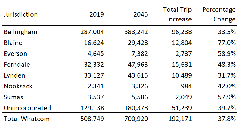
Overall, the model forecast calculates an increase of nearly 200,000 vehicular trips from 2019 to 2045, an increase of 38 percent.
5.1.2 Commute Trips
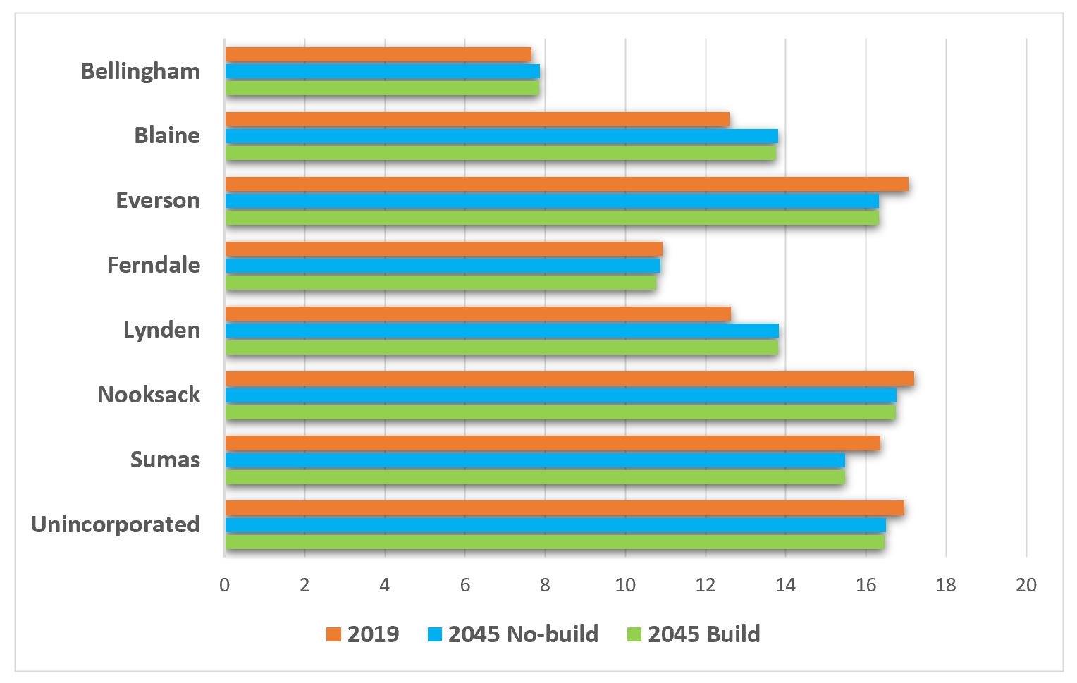
Trips for work and work-related travel account for nearly a quarter of all daily trips in the region and is the second-largest share of daily trips. The morning commute time that is estimated in the travel demand model refers to the average amount of time it takes to travel from home to place of employment. Figure 8 illustrates the average commute time for jurisdictions. The City of Bellingham continues to have the lowest commute times, understandably so because its urban area contains the most residences and employment options. Conversely, rural communities have higher commute times. Overall, there appear to be slight variations in comparing 2019 with the 2045 build and no-build forecast.
Figure 8: Travel Time to Work
5.1.3 Vehicle Miles Traveled and Vehicle Hours Traveled
Vehicle miles traveled (VMT) is a common measurement of cumulative distances driven by all vehicles on the region’s roads throughout a typical 24-hour day. VMT by internal-combustion vehicles is an input for estimating greenhouse gases (GHG) emissions. The Whatcom County Climate Action Plan’s first strategy to reduce transportation related GHG is through the reduction of single occupancy vehicle’s VMT (CIAC, 2021). Vehicle hours traveled (VHT), the cumulative time that vehicles spend driving during a specific time period, reflects the efficiency of vehicular movement throughout the road network. VHT is a product of factors such as travel speed, roadway capacity, and congestion. Figures 9 and 10 list the growth in average daily VMT and VHT from 2019 to 2045.
Figure 9: Daily Vehicle Miles Traveled from 2019 to 2045
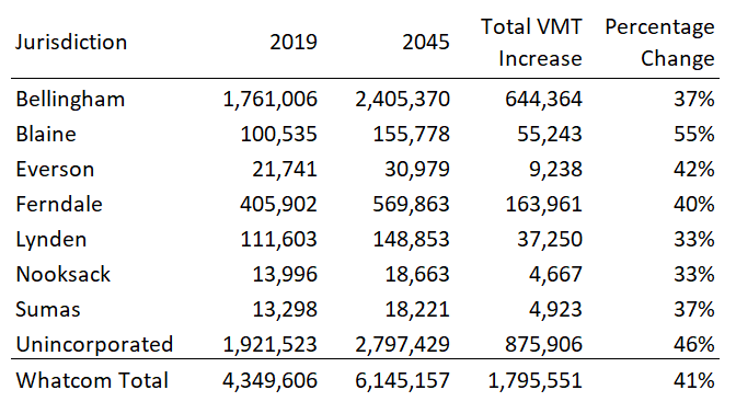
Figure 10: Daily Vehicle Hours Traveled from 2019 to 2045
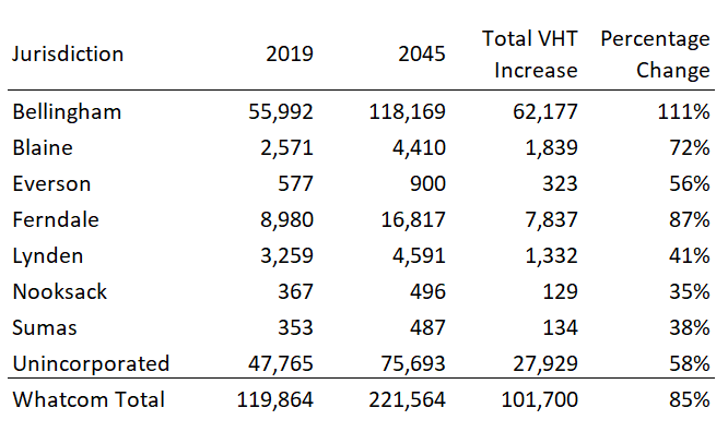
As indicated in the tables, both VMT and VHT increase substantially as a result of the projected growth in households and employment among the jurisdictions. It is not a surprise that the higher population areas, City of Bellingham and unincorporated Whatcom County, create the highest total of miles travelled along with the most amount of time spent on the road. The forecast estimates unincorporated Whatcom County to create the highest increases in VMT while the City of Bellingham the highest increases in VHT.
A comparison of the 2045 build and no-build scenarios (Figure 11) shows the reductions in VMT, VHT, and hours spent in traffic that are gained by implementing the projects in Way to Go, Whatcom. Although the improvements appear small, these reductions reflect modest changes to vehicular activities throughout the entire regional network and are solely based on planned projects that impact roadway capacities.
Figure 11: Comparison of Daily VMT and VHT by 2045 Scenario

5.2 Volume-over-Capacity Ratio and Daily Travel
The volume, or number of vehicles, on a particular roadway segment, divided by the maximum number of vehicles that the segment can accommodate without congestion, it’s capacity, estimates a common measure of system performance known as the volume-over-capacity (V/C) ratio. The lower the V/C ratio means that there are fewer vehicles operating on a certain segment of roadway, or less congestion; conversely a higher V/C ratio indicates more congestion when the volume comes close to, or exceeds, the road capacity. A V/C greater than one is considered failing. The V/C ratio is currently used to determine a roadway segment’s level of service (LOS) that describes the operating conditions a driver will experience when traveling at a specific time of day.
By analyzing roadway segments during peak hour traffic conditions, including approaches to problematic intersections, planners and engineers can determine which locations require additional analysis that may lead to improvements. Figures 12-14 illustrate the V/C ratios and average daily traffic for road segments on the regional transportation network during afternoon (p.m.) peak hour for 2019 and the 2045 no-build and build scenarios.
Figure 12: 2019 Base Year Volume-Over-Capacity Ratios and Average Daily Traffic
Figure 13: 2045 No-build Volume-Over-Capacity Ratios and Average Daily Traffic:
Figure 14: 2045 Build Volume-Over-Capacity Ratios and Average Daily Traffic:
5.3 Freight
The movement of commercial goods, commodities and cargo has a substantial impact throughout the Whatcom region. Whatcom County, being on the U.S.- Canada border, has important international transportation links. The Cascade Gateway ports of entry serve very high volumes of trade and travel including trucks, personal vehicles, buses, rail, and pipeline. During the summer of 2019 before the COVID-19 pandemic, the freight dedicated Pacific Highway Port-of-Entry reached over 65,000 commercial trucks a month during the summer. (IMTC, 2021) Traffic count data collected by WCOG at over sixty locations throughout Whatcom’s cities estimated that commercial trucks accounts for over 10 percent of the total vehicles using regional roads.
Many Whatcom residents are now receiving daily goods and service deliveries along with standard mail. According to the Whatcom Regional Transportation Study, nearly 15 percent of adults reported a delivery or service on an average weekday (RSG, 2019). The regional model’s 2045 forecast estimates up to 63 percent increase in freight trips that are largely influenced by forecasted employment growth. WCOG continues to seek quality data to quantify and examine the impacts of increasing deliveries and shipment activities on the regional system.
5.4 Active Transportation
Active transportation is non-motorized modes of travel such as walking, biking or rolling. Data collected from the 2018 WCOG travel study estimated that 12.6 percent of trips were made by walking, 3 percent of trips by bike, and 1.1 percent other (e.g. skateboarding or scooter). In all, that’s nearly 17 percent of trips that are non-motorized and using the roadways along with motorized travel. (RSG, 2019)
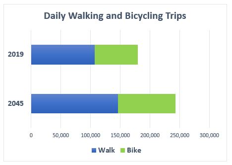
Local jurisdictions are continuing to integrate non-motorized facilities into the road network towards the complete streets and/or complete networks concept. Although the regional network mostly serves motorized activities, many urban-area roads provide sidewalks connectivity for pedestrians and marked lanes for bicycle travel. Many rural roads provide wider shoulders to accommodate bicycle travel. The majority of non-motorized trips occur in urban areas where the percentage of these trips are more than double those made in rural areas. (RSG, 2019) These trips impact the regional transportation system’s performance by providing connections to destinations as well as connections to other modes of travel, such as transit or ridesharing. Walking and rolling trips can also reduce traffic congestion by replacing motorized trips and results in less environmental degradation. By applying today’s travel behaviors towards the year 2045, bike and walk trips are forecasted to increase by 37 percent and 34 percent respectively.
Figure 15: Walking and Biking Trips for 2019 and 2045 Scenario
5.5 Transit
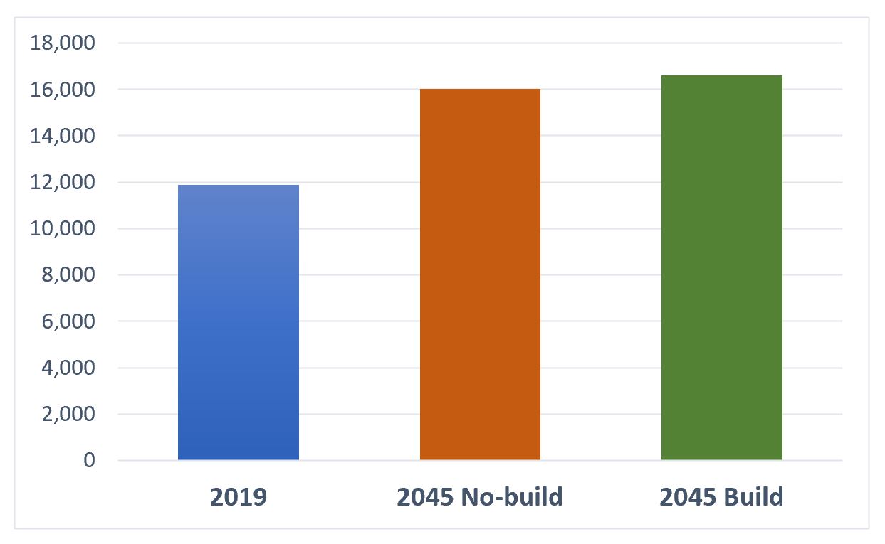
Nearly three percent of all trips made in Whatcom County are transit. The primary transit service provider in the region, the Whatcom Transportation Authority (WTA), adopted the WTA 2040 plan in early 2022. The plan outlines a “sustained investment” transit services scenario that incorporates a moderate expansion based on current fiscal constraint assumptions. This serves as a basis for Way to Go, Whatcom. Comparing the base year transit trips with the 2045 no-build forecast and 2045 build forecast results in transit trip growth of 35 percent and 40 percent, respectively.
Figure 16: Growth in Daily Transit Trips
Most transit trips are forecasted to occur in Bellingham. However, small urban and rural areas are also projected to increase transit trips. The WTA 2040 plan includes service areas where on-demand service will replace or enhance fixed-route service, thereby improving access to transit. In addition, WTA plans to expand coverage and frequency for much of the WTA service area thereby expanding travel choice, access to jobs, health care, shopping, and education. (WTA, 2022)
